Defining ‘urban,’ ‘rural,’ and ‘in-between’ across the Carolinas Urban-Rural Connections region
When you think of ‘urban’ you might picture canyons of glass and steel skyscrapers, while the word ‘rural’ might bring to mind pastures and rolling farmland. But what do those words, precisely, mean?
In reality, the terms rural and urban are not binary, but instead represent a spectrum or continuum along which places fall. Most places are not completely one or the other, but fall somewhere in between, making clear categorization difficult. However, there are a number of classification systems that exist to attempt to do just that. Using 2010 Census data, we mapped several of these systems for our 32-county region, which are presented in the graphic below. Use the tabs at the top to explore each system.
If you want to find information for a specific area, check out the Rural Health Information Hub’s Am I Rural? Tool, which shows whether a specific location is considered rural based on various definitions, including those used as eligibility criteria for federal programs and grants.
Census Bureau
Census Bureau
The U.S. Census Bureau’s scheme is the simplest in terms of categories, as there are just two: urban and rural. But they are designated at the census block level, which is the finest scale census data are available. For both of those reasons, the Census definitions form the building blocks for many of the other classification systems.
The U.S. Census Bureau uses population density and other measures of development density to define urban areas. In doing so, it is able to delineate an urban area’s physical footprint more precisely than municipal boundaries would allow.
Urban areas are further distinguished into two categories: Urbanized Areas, which have populations of 50,000 or more, and Urban Clusters, which have populations between 2,500 and 50,000. Rural areas encompass all population, housing, and territory not included within an urban area. For a more in-depth explanation of the process, check out Defining Rural at the U.S. Census Bureau.
In the 32-county region, there are currently 10 urbanized areas and 34 urban clusters. Together, these urban areas encompass 68 percent of the region’s population and 19 percent of its land area.
This system offers the most precise definitions of urban and rural areas, but is difficult to use to describe or compare both types of places because little data exist at this fine scale. Data are more widely available at the county level, so classification schemes at this level are necessary to bridge the gap. The most basic of these is from the Office of Management and Budget, described in the next tab.

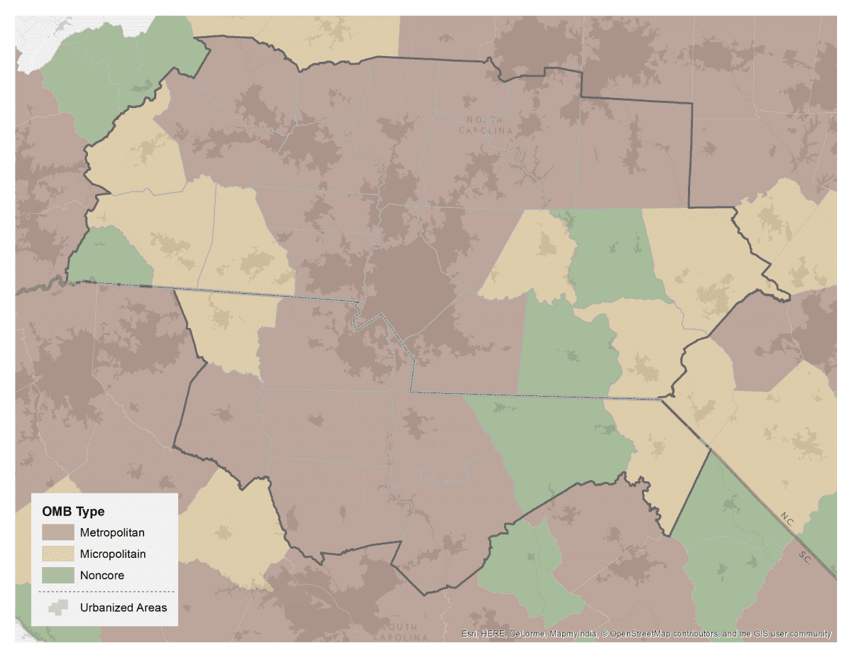
OMB
Office of Management and Budget
The federal Office of Management and Budget (OMB) defines metropolitan and micropolitan statistical areas using population, urban areas, and commuting patterns. Both of these areas include an urban core and the adjacent counties that have a high degree of economic and social integration with the core. These areas are based on counties, and thus this classification system is often used to approximate urban and rural at the county scale.
A metropolitan statistical area (MSA) must include at least one urbanized area of 50,000 people or more. At the county scale, an MSA includes the county (or counties) that contains the urbanized area plus adjacent, outlying counties where 25 percent of employed residents work in the area or 25 percent of jobs are filled by residents of the area. All counties that are part of a metropolitan statistical area are considered “metropolitan.” The majority of the 32-county region falls in this category, with 20 of the 32 counties, 83 percent of the population, and 63 percent of the land area.
The criteria that define a micropolitan statistical area are similar to that of MSAs, but instead of an urbanized area, a micropolitan statistical area must include an urban cluster of 10,000 to 50,000 people. In the 32-county region, 8 counties fall in this category, accounting for 13 percent of the region’s population and 24 percent of its land area.
All remaining counties that are not part of a metropolitan or micropolitan statistical area are categorized as “non-core”. Only 4 of the region’s counties (Anson, Fairfield, Montgomery, and Polk) are in this category, representing 3 percent of the population and 13 percent of the land area.
This is one of the most common systems used to define urban and rural. However, it’s often problematic, because in reality, metropolitan and micropolitan counties include rural territory and noncore counties include urban areas. In fact, half of the rural population in the U.S. is actually found within metropolitan counties, and another quarter within micropolitan counties. This is even more pronounced in the 32-county region, where two-thirds of the rural population lives in metropolitan counties, and nearly a quarter in micropolitan counties.
RUCC
Rural Urban Continuum Codes
The U.S. Department of Agriculture’s Economic Research Service has created several classification systems based on the OMB categories that provide a more nuanced picture, especially for non-core areas. One is the Rural Urban Continuum Codes (RUCC), which divides metropolitan counties based on the total population of the metro area and nonmetropolitan counties by their urban population and location relative to a metro area.
Metropolitan
- Counties in metro areas of 1 million population or more: At 2.5 million in population, the 10-county Charlotte metro area is in this category. Together, these counties account for 61 percent of the region’s population and 31 percent of the land area.
- Counties in metro areas of 250,000 to 1 million population: The other MSAs in the region fall in this range. Like the first tier, 10 counties are included in this second tier and represent nearly a third of the land area, but (unsurprisingly) they represent a smaller share of the region’s population (23 percent).
- Counties in metro areas of fewer than 250,000 population: Since all of the metro areas touched by the region have populations over 250,000, none of the region’s counties fall in this category.
Non-Metropolitan
- Urban population of 20,000 or more: Five counties fall in this category, and all but one (Richmond) are adjacent to a metro area.
- Urban population of 2,500 to 19,999: Six counties fall in this range, all of which are metro-adjacent.
- Urban population of less than 2,500: Just one county in the region meets this criteria: Polk.

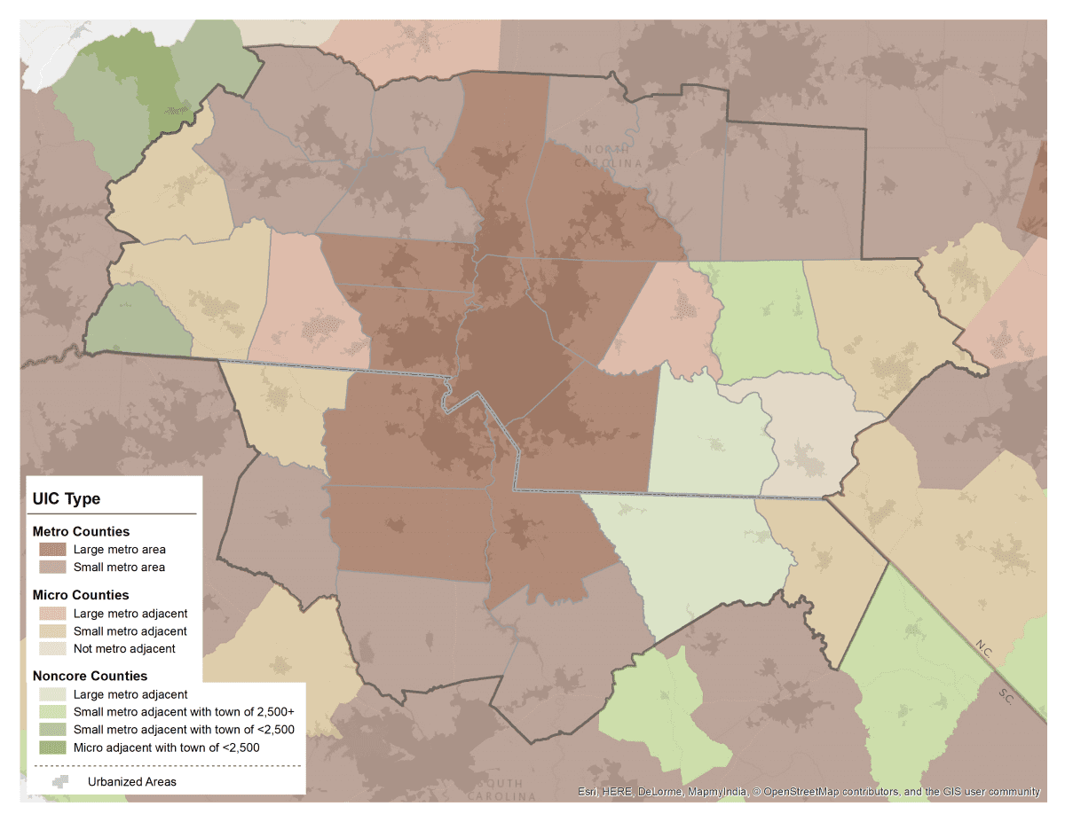
Urban Influence Codes
Urban Influence Codes
Another OMB-based system from the U.S. Department of Agriculture and Economic Research Service is Urban Influence Codes (UIC). This system divides metropolitan counties based on the population of the metro area, micropolitan counties based on their location relative to a metro area, and noncore areas based on their location relative to a metro or micro area and the size of the largest town.
Metropolitan
Metropolitan counties are split into two categories: those in metro areas with more than 1 million in population and those with less. In the 32-county region, this is essentially the same as the RUCC distinction, with the 10 counties in the Charlotte metro in the first tier and the other 10 in the second tier.
Micropolitan
Micropolitan counties are divided into three categories: those that are adjacent to a large metro area, those that are adjacent to a small metro area, and those that are not adjacent to any metro area. In the 32-county region, most (five) micropolitan counties are adjacent to a small metro, two are adjacent to a large metro (Cleveland and Stanly), and only one (Richmond) is not metro-adjacent.
Non-core
Noncore counties are subdivided into seven categories, but only three are represented in the 32-county region: those that are adjacent to a large metro area (Anson and Fairfield), those that are next to a small metro area and include a town of at least 2,500 (Montgomery), and those that are next to a small metro area and include a town of less than 2,500 (Polk).
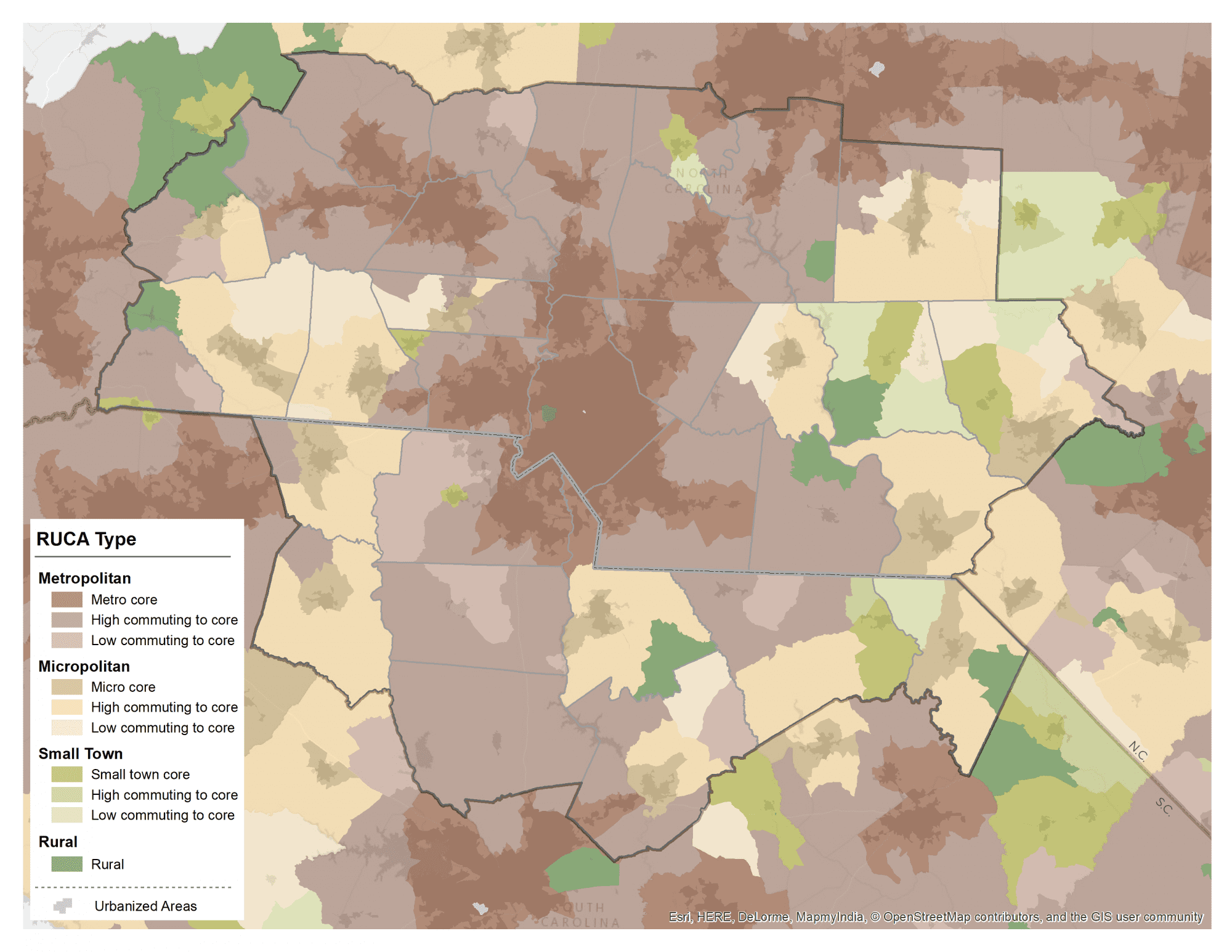
RUCA Codes
Rural Urban Commuting Area codes
The last of the U.S. Department of Agriculture and Economic Research Service systems is a more nuanced and geographically fine-grained classification system called the Rural Urban Commuting Area (RUCA) codes. Instead of counties, this system is built on census tracts, which are classified based on urbanization and commuting patterns.
Metropolitan
- Metropolitan area core, local commuting within urban area
- Metropolitan area high commuting, 30 percent out-commuting to urban area
- Metropolitan area low commuting, 10-30 percent out-commuting to urban area
Micropolitan
- Micropolitan area core, local commuting within large urban cluster
- Micropolitan high commuting, 30 percent out-commuting to large urban cluster
- Micropolitan low commuting, 10-30 percent out-commuting to large urban cluster
Small Town
- Small town core, local commuting within small urban cluster
- Small town high commuting, 30 percent out-commuting to small urban cluster
- Small town low commuting, 10-30 percent out-commuting to small urban cluster
Rural
- Rural areas, local commuting or commuting to another rural area
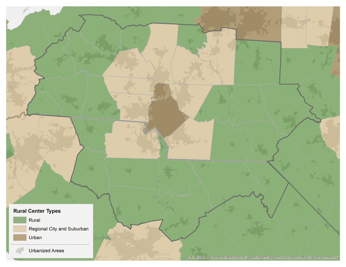
NC Rural Center
NC Rural Center
The North Carolina Rural Center uses a simple classification system based on population density to categorize the state’s counties. Rural counties have a population density of 250 people per square mile or less. Regional City and Suburban counties have between 250 and 750 people per square mile. Urban counties have more than 750 people per square mile. We applied this methodology to classify South Carolina counties as well in order to capture the full 32-county region.
Rural counties feature more prominently in this classification scheme than any of the others, with 22 of the 32 counties in the region, accounting for 70 percent of the region’s land area. However, they still account for only 34 percent of the region’s population. The nine Regional City and Suburban counties contain 41 percent of the region’s population but only 27 percent of the land area. Mecklenburg is the only county in the region that is considered Urban.
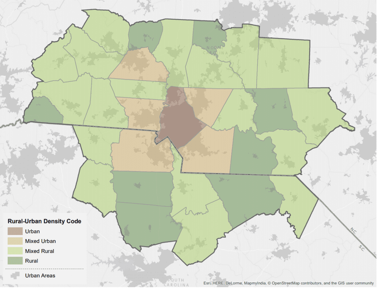
Rural-Urban Density Codes
Rural-Urban Density Codes
In 2005, a scholar at the University of Illinois (Andrew Isserman) proposed a new county-based typology consisting of four categories, based on: population density, the share of the population living in urban areas (as defined by the Census), and the presence and size of those urban areas.
Rural counties are those with a population density of less than 500 people-per-square-mile (ppsm), 90 percent of their population in rural areas, and no urban area of 10,000 people. Eight counties in the 32-county region meet these criteria for rural. Together, they account for 24 percent of the region’s land area but only 7 percent of its population.
Urban counties are those with a population density of at least 500 ppsm, at least 90 percent of the population in urban areas, and at least 50,000 people living in the urbanized areas. Mecklenburg County is the only county in the 32-county region that meets the criteria for urban.
Counties that meet neither the urban nor rural county criteria are considered mixed, and are subdivided based on a second population density threshold. Mixed rural counties have a population density of less than 320 ppsm, and mixed urban counties have a population density of at least 320 ppsm.
Eighteen counties in the 32-region are considered mixed rural. Together they represent 41 percent of the region’s population and 58 percent of its land area. Although only five counties in the region are considered mixed urban (Cabarrus, Catawba, Gaston, Union, and York), they comprise just over 25 percent of the population and 15 percent of the land area.